Sunday 22 June 2008

Trip Report: Mayar and Dreish

After a very long day out yesterday I was looking for something a little more relaxed today. The very heavy overnight rain eased on the drive round from the hostel and by the time I reached the Glen Doll car park (£1.50) it was amazingly dry if cloudy.

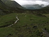
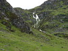
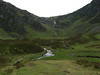
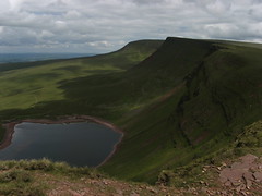
the route itself follows forestry tracks signed to Corrie Fee passing several geocahes en route. On reaching the deer fence the corrie opens out before you with a stunning waterfall present after heavy rain.

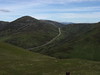
The Track stays dominant climbing steadily on the left side of the falls before angling further left onto the fell side. a steady climb then brings you out on the summit.

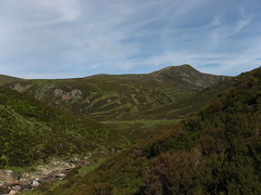
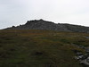
The forward route is now a clearly visible path although the final climb to the trig is tricky in thick mist as it lacks a cairns as it heads across the mountain face towards Dreish and its trigpoint

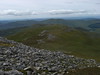
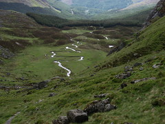
A return to the last coll allows a cut across to the route down over tracks and forest drives almost directly to the cars.

A lovely shorter day (5 hours including looking for 7 caches) but if you can one to save for a dry day after heavy rain to get the corrie at its best


Additional Images
Corrie Fee, Angus, Scotland Corrie Fee, Angus, Scotland Corrie Fee, Angus, Scotland

Saturday 21 June 2008

Trip Report: East of the Devils Elbow

The area around Glenshee offers some of the fastest number crunching for the Munro bagger. West of the road the Cairnwell group is little more than an afternoon stroll but the real value comes to the east.

With a second driver it is possible to leave the road from the layby about 1 mile south of the ski centre and pick up a route that takes you though an open river valley onto a broad ridge then onto a plateau and finally a Pennine style hack over largely untracked ground to pick up a grand total of 6 Munros in a day.

As already suggested it is a day of contrasts. The initial climb is steady although picking a good route out from the river onto the ridge is vital to save effort. The crossing over Creag Leacach to Glas Maol is then reminiscent of the northern Carneddau and at this point it is always possible to head off west back down to the southern end of the ski centre car parking. Instead keep onward via the remnant snow patches to one more Munro on a distinct ridge path then two over open wet ground with reasonable tracks before returning from Tolmount for a final climb to Carn na Tuirc.

Care is needed here especially in mist as the tracks are indistinct and a direct bearing takes you over a steep slope with hidden crags. Instead head south four about 250m before striking out for the final summit.

Leaving the last top head North into the v of the stream shown on the 25k mapping before picking up a welcoming track back to the road


More images
pdr_20080621_3212 pdr_20080621_3214 pdr_20080621_3215 pdr_20080621_3221

Friday 20 June 2008

Trip Report: Mulloch Hill, St Johns Town of Dalry

It is quite common for me to make a short sprint up a roadside hump to a trigpoint but very rare I blog about them. Mulloch hill is however worth the effort.

Located just SE of the grandly named St Johns town of Dalry on the main road between Castle Douglas and Ayr this makes for a nice half hour break.

Parking is provided in a large lay by and a marked "core path" leads up the hill and thought the trees to within 200m of the summit. The final climb just after a stile is via a bracken slope but you cant win them all.

But why come here simply for the view you have an ever changing 360 degree view of the surrounding Southern upland terrain. Put simply a great way to break a long drive

Friday 13 June 2008

Trip Report : Carmarthen Fan

It hard to believe that so close to Swansea the terrain can get so remote but a trip into the Carmarthen Fan from the Tawe Valley is just that remote.
I parked up at the church just south of Tafarn y Garreg on the main Sennybridge-Ystradgynlais road and then headed a little way south to pick up the footpath and bridleway into the heart of the Fan.

Three short diversions over the local Dewey tops around Tynwalter broke up he monotony and in themselves would have made a nice short trip for a family (if so do TW first then S-N on the other two easier climbing). Then it was just a case of following the variable visibility path into the valley below Garreg Las.

From here the character changes the out and back to the cairn is a prelude to the main scarp walk most of which is in the photo. For first timers I would say keep to the edge all the way the views are great and the paths clear, however for me the final climb to "Brycheniogs Trig" was on the newer direct line that is now far more visible than when I first climbed it over 15 years ago.

The descent to the car is over Fan Hir and down its largely easy ridge though car on the knees is required in the very final stages.

All told a long remote and rough day best in sun or with a reliable GPS/ compass in low cloud


More photos from the walk here http://www.flickr.com/photos/22109627@N03/archives/date-taken/2008/06/13/